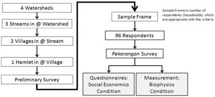
The pekarangan plot survey samples were designed through three levels of consideration following the preceding process. The first level of consideration of this design is the different stream directions of the rivers where the watershed lies in either southern areas (SAs) and northern areas (NAs); this is called orientation level. The two sides of the flow of rivers that originate from the same mountain are expected to be almost homogeneous and have almost the same parent soil material, yet hypothetically have different climate conditions. A distinct variation of parent soil material may occur within the mountain at the water sources. In general, the NA watersheds were more humid than the SAs; because of this variation in agroclimatic zone, the NAs tend to have better agricultural activity performance than the SAs.
The second level of consideration is that of agroecological zoning, which in this study is represented by elevation stratification within a watershed where a pekarangan lies. There are three levels of stratification: 0-300 m, 300-700 m, and >700 m above sea level (m a. s.l.), called stream level. Ochse, as cited by (Harjadi 1989), a Dutch horticulturist working in Indonesia in the colonial era, used the 700 m a. s.l. level as a threshold between lowland and highland. Ochse said that
|
Fig. 17.4 Flowchart of the research process from preliminary to main survey. Sample frame is number of respondents who have pekarangan and other agriculture land (OAL) size appropriate to group criteria |
above 700 m a. s.l. coconut, a plant grown widely in Indonesia, cannot grow productively. Therefore, in this survey we use this elevation threshold. The 300700 m a. s.l. zone was used in concordance with bioclimatic conditions (Arifin et al. 2001). This zone is a transitional zone, where there is high biodiversity of plant species mixed from upper or lower zones.
The third level of consideration is the scale of ownership. At each respective stream level, four groups of pekarangan ownership were defined in a purposive random village. Those four groups are G1, with a pekarangan size less than 120 m2 with no other agricultural land (OAL), G2 (pekarangan <120 m2 with OAL < 1,000 m2), G3 (pekarangan 120-400 m2 with no OAL), and G4 (pekarangan 120-400 m2 with OAL < 1,000 m2) (Figs. 17.4, 17.5) (Arifin et al. 2008).
Following the three levels of sampling design just described, two villages were randomly selected to obtain averaged data. Then, in each village four groups were selected based on the sample frame. In total, 96 pekarangan that were distributed among four watersheds were investigated (Fig. 17.6).
The sampling methods were based on region, orientation, streams, villages, and location relative to the national parks. In each respective area, a sample frame consisting of group levels of pekarangan ownership were chosen randomly (Fig. 17.4). The consideration is the size of pekarangan and the ownership of other agricultural land (OAL). Representative samples were collected by (1) village selection, (2) pekarangan utilization, and (3) sample frame requirement. Four surveyors conducted those activities: two surveyors interviewed asked the respondents while the other two measured the pekarangan biophysically.
|
Fig. 17.5 Schematic diagram of group criteria: G1, G2, G3, G4. G1 are households with pekarangan less than 120 m2 in size but that do not have OAL. G3 are households with pekarangan between 120 and 400 m2 in size that have OAL but its size is less than 1,000 m2. The scheme is drawn in proportional size |
|
Fig. 17.6 The sampling design shows a total of 96 respondents distributed in four watersheds. The process of sampling design is as follows: there is one region in West Java, two orientation levels (NAs north areas, SAs south areas), three stream levels (UP upper stream, MD middle stream, DW down stream), two villages (V1 and V2 were randomly selected), and four group levels (G1, G2, G3, and G4 based on sample frame) |


