Many visitors to the outdoors are not experienced in the use of map and compass. They are apprehensive about following a trail unless they know where it will lead them, and that they will not get lost. Hence some kind of waymarking is frequently necessary to help visitors enjoy the experience of exploring the outdoors.
If the Recreation Opportunity Spectrum is adopted as a planning tool, or if a trail system graded for a range of ability levels is developed, then the map and compass enthusiast can be catered for by unmarked trails, while the inexperienced visitor can follow marked ones.
Waymarking systems will vary depending on the type of trail development. Often several trails are developed from a particular car-parking area. These might be of different lengths, cater for different degrees of ability or lead to different points of interest. Often they might share sections of the route, with shorter paths diverting from longer ones and perhaps rejoining them closer to the end. Where such
 |
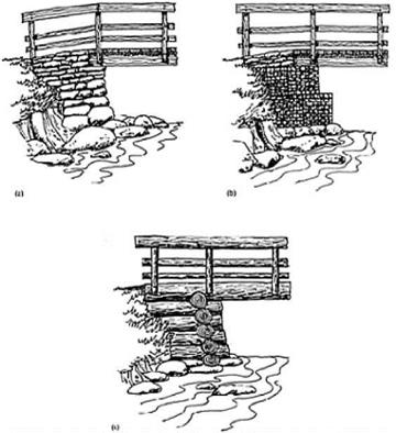
Three types of abutment: (a) Natural stone construction, graded from the largest size at the bottom to the smallest at the top. (b) Gabion baskets made from galvanized weldmesh packed with stone from the site. (c) Log cribwork is a traditional method appropriate for use in forests. The cribwork is backfilled with stones and soil.
|
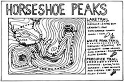
An example of a trail entrance panel showing routes and giving information about the length, average duration and path conditions to be expected of each trail. |
path systems exist, the waymarking has to differentiate between each path so that the points where routes diverge are obvious and not missed. One common and well-tried method is to colour-code each trail. A leaflet or board at the entrance to the trail (or trailhead) can be used to show, in map or pictorial form, the trail system, the colour coding, the difficulty, the expected duration and all the points of interest. The colours chosen should avoid those that people with colour blindness cannot identify—for example, certain shades of red and green.
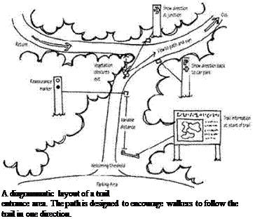
The method of waymarking also depends on whether the trail should be walked in one or either direction. This choice may be important if the gradients vary so that the steepest slopes are ascended rather than descended, or whether particular landmarks or attractive features should be seen in a particular order. Another reason for a one-way circuit is if there is interpretation along the trail that tells a story in a particular sequence (see Chapter 13). Finally, when trails are used heavily a one-way route ensures that walkers are not always meeting people coming towards them so the route might feel emptier than it really is.
The design of the trail entrance is crucial to this: it can be laid out to steer people in the right direction,
 |
and if a one-way route is chosen the waymarking need only be seen from one direction, perhaps reinforced by the use of arrow symbols.
If a two-way route is required then the waymarking must be effective from either direction, and this is crucial at junctions. The position of waymarkers has to be planned from the walkers’ point of view by walking the trail, resolving where there might be confusion (for example at junctions), periodic reassurance of the route, and the best locations for signs in terms of visibility. A comprehensive map or schedule should be prepared detailing every marker so that it is known exactly how many are needed, their particular function and their precise location.


