Some similarities can be identified between policies in Delft and development guidelines introduced in
|
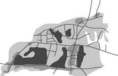
] Urban agriculture reserve areas ] Urban development areas ] Buildings – Roads Figure 23.2 |
Nepal’s Kathmandu Valley. An extensive planning exercise undertaken for the Madhyapur Thimi Municipality, located in the Kathmandu Valley, has defined a number of urban agricultural reserve zones, which have been incorporated into the municipality’s development plans (Weise and Boyd, 2001). The reserves are not necessarily permanent as the municipal plan allows for the incremental release of land for commercial development. In this respect proposals are similar to those in Delft, namely that planners have yet to be convinced that urban agriculture can be considered as beneficial as conventional urban development. Agreement to incorporate the urban agriculture reserves into the municipal plan was not without opposition, in the main from middle class individuals who had intended to build detached houses on small plots. A portion of land has been set aside for housing, but the urban agriculture reserves in Madhyapur Thimi Municipality are extensive. We would estimate that if a similar proportion of land was allocated in European cities, they would be close to self-sufficient in fruit and vegetables. But one imagines the opposition to such proposals if powerful developers had plans for particular pieces of land. This highlights the need for planning for urban agriculture at an early stage in the planning process, preferably before land has been sold to individuals for the purpose of house building.
The Madhyapur Thimi Municipality has identified a number of significant benefits resulting from the inclusion of urban agriculture reserves.
By defining urban agriculture reserves, financial resources can be targeted more efficiently, as areas of land are identified which do not require the installation of complex supporting infrastructure. This allows the concentration of resources within areas identified for urban development. Resources can be used to promote denser urbanisation and the efficient use of land. Furthermore, potential problems, such as processing biodegradable waste and sewage, can be turned into solutions, i. e. if this waste is used as an agricultural resource, for example as compost. By having a specific policy supporting urban agriculture, the release of any agricultural land for development can be regulated and controlled.
GABORONE, BOTSWANA
In Gaborone, capital city of Botswana, a number of integrated urban agriculture projects have been instigated. In at least one case, innovative planning has made a connection between waste from sewage works and urban agriculture (Cavric and Mosha, 2001).
Gaborone has undergone dispersed suburban expansion since independence in 1966. The city
 |
 |
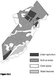
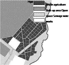
has always been reliant on food imported from beyond its boundaries (Mosha and Cavric, 1999). In the Glenn Valley area of Gaborone several parcels of land have been identified as sites for urban agriculture. It is estimated that these should make the city self-sufficient in food production. One of these sites is of particular interest as it is adjacent to a sewage works and bounded by the Notwane River. Wastewater from the works can be used to irrigate crops, though if industrial contaminants are present wastewater should be reserved for non-edible crops such as fiber or wood. In the Glenn Valley area individual farmer’s plots vary in size between one and a half and four hectares and
are laid out back to back in order to minimise the number of access roads required.
The plots adjacent to the sewage works are likely to be used for cut flowers and ornamental plants, similar to the floral organoponics found in Cuba. We can use this example to imagine how such an area, including the urban agriculture plots, could become a new kind of urban park. As designed, the Glenn Valley urban agriculture site is laid out as a matrix of rectangular plots. If these plots are separated to allow for continuous paths between them, a network of accessible public routes could overlay the urban agriculture fields, creating what we
Figure 23.3 Glenn Valley, Gaborone, Botswana.
Figure 23.4 Glenn Valley (detail), Gaborone, Botswana.
term ‘LeisurEscapes’. This is another example of horizontal intensification, in this case intensifying a productive landscape by making a connection between the river and the city, while providing new spaces for play and relaxation.


