Many complex land covers exhibit similar spectral characteristics making separation in feature space by simple per-pixel classifiers difficult, leading to inaccurate classification. Therefore, an object-based classification is a potential solution for the classification of such regions. The specific benefits are an increase in accuracy, a decrease in classification time and that it helps to eliminate within-field spectral mixing (Berberoglu et al., 2000). The object-based classification approach involved the integration of vector data and raster images within a geographical information system (GIS) and enabled the knowledge free extraction of image object primitives at different spatial resolutions, the so-called multiresolution segmentation. The segmentation operated as a heuristic optimization procedure which minimized the average heterogeneity of image objects at a given spatial resolution for the whole scene (Bian et al. 1992). The objective was to construct a hierarchical net of image objects, in which fine objects were sub-objects of coarser structures. Due to the hierarchical structure, the image data were simultaneously represented at different spatial resolutions. The defined local object-oriented context information was then used together with other (spectral, form, texture) features of the image objects for classification. At the next stage, supervised per-field classification was performed using the nearest neighbor algorithm utilizing field boundary data generated as a result of the segmentation procedure. Objects are segmented in the image and all objects are created object layer. Two or more object layer is called object hierarchy (figure 12).
|
Fig. 12. Image – object hierarchy |
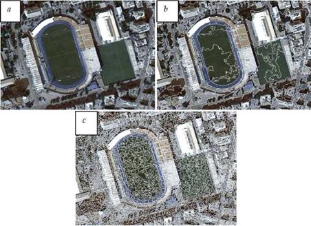
Basically, there are three steps in object based classification as segmentation, classification and per field integration. An image was divided segments dependent on pixel spectral similarities, structure of the image and surface texture characteristics. This progress is up to variables like scaling factor, smoothness vs. compactness and shape factors (figure 13).
|
Fig. 13. (a) non-segmented image, (b) segmented image using scale factor 50, (c) segmented image using scale factor 10. |
Each segments are contained a group of pixels and scaling factor is defined minimum pixel counts which have similar spectral characteristics in a segment. Compactness and smoothness are important for creating pixel groups. Shape factor is deal with boundary of a segment. Scale factor is variable according to the study scale and ideal scale can be found trying different scale factors. When the sensitive LUC analyze is necessary, compactness factor should be high and smoothness should be low (e. g. vegetation classification in CORINE level 3 and more). Shape factor is very important if shape of the LUC objects have a dominant characteristic (e. g. agricultural lands, roads and buildings).
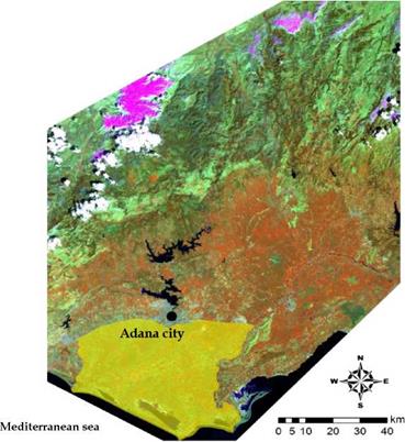
Each LUC class can be defined using different dataset and rules according to characteristics of LUC. In this chapter, object and pixel based classifications were evaluated in a Mediterranean agricultural land called Lower Seyhan Plane (LSP) (figure 14).
Especially in agricultural land, object based classification is the most suitable technique. Most of the agricultural fields has regular shape and contains one dominant crop in a field in one time. In winter time dominant crop is wheat in the study area, summer period includes corn, soybean and cotton. Mapping the farmlands may be inappropriateusing only one optical image. Multitemporal object based classification approach was used to map LUC in LSP. Two Landsat TM images from March and April were classified together, and June, August images and some of physical variables like distance from cost line and distance from built up areas were added to create rules for each LUC. In this chapter only winter crop pattern discussed using LDA classifier, and rule dependent object based classification were compared each other to see accuracy difference in each LUC (figure 15).
|
Fig. 14. Lower Seyhan Plane (in yellow) |
 |
|
 ‘ Щ I I Baregrourifcs;^. Fallow
I Wheat ”■*
I Natural grassland
____ [ Sand dunes
I qour orange
Potato
Bulrush
Onion
Water bodies
Saline veg. Settlement
Fig. 15. LDA pixel based and object based classification results of LSP
Pixel based LDA classifier was failed in onion, sour orange, settlement, bulrush and sand dunes using March and April images. However, June and August images, distance from built up areas, distance from cost line were integrated in rule dependent object based classification and kappa coefficient was increased 28% in general. Sour orange, bulrush, sand dunes and settlement accuracy were raised impressively. One of the advantages in rule dependent classifiers was allowed to add new class during the classification. In this study, saline vegetation and natural grasslands were included to improve classification accuracy (table 12).
|
LUC |
Object based classification |
LDA |
Difference |
|
Wheat |
%100 |
%100 |
– |
|
Onion |
%48 |
%15 |
%33 |
|
Potato |
%84 |
%84 |
– |
|
Citrus |
%95 |
%23 |
% 72 |
|
Water bodies |
%100 |
%100 |
– |
|
Fallow |
%96 |
%96 |
– |
|
Bareground |
%85 |
%89 |
%4 |
|
Bulrush |
%95 |
%34 |
%61 |
|
Forest |
%100 |
%88 |
%12 |
|
Sand dunes |
%100 |
%40 |
%60 |
|
Settlement |
%95 |
%30 |
%65 |
|
Natural grasslands |
%74 |
– |
– |
|
Saline vegetation |
%95 |
– |
– |
|
Overall Kappa |
%90 |
%62 |
%28 |
|
Table 12. Kappa accuracy of each LUC and difference between object and pixel based classifications |


