As a basis, support was founded in the PIOM (Integral Plans of Ordering and Management) applied by now to seven streams in the area of Medellin. Those were analysed in searching their landscape approaches, if any, but also because of the wide and up to date basic information that they could provide, avoiding invert efforts in a job already accomplished.
The AMVA (Environmental Authority of the Aburra valley) has produced a PIOM Methodology to be followed in the case of every one of Medellin’s streams. It is worth to annotate that landscape factor is absent of all considerations, as it is frequent in local public documents. In the scarce cases that landscape is mentioned it is addressed as the vegetation piece of urban design, or in any case as a secondary matter.
In their development, some PIOM make emphasis on one component while others do on others. In order to get a balanced approach, the established components were analysed on the same basis.
The hydrologic component was analysed under general concepts of water cycle and functioning, while the major and minor watersheds were revised in the territorial ordering
context[6]. Within Medellin’s jurisdiction[7], more than 400 streams and 60 minor watersheds are reported; those conform 6 watersheds that tribute to the Aburra river major watershed, a considerable water presence. In a closer analysis conflicts between streams, resource use, urban uses or mistreatment were studied.
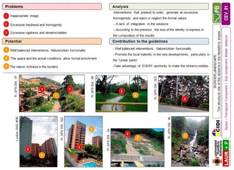
After visiting several cases, observe, perceive experimenting and talking to local people, the analysis from each component was captured on a template designed to gather in an organized way the contributions from each sub-component to the landscape diagnosis. One of the records obtained from the spatial/perceptual landscape analysis is shown ahead as an example, selected because in some way it gathers other topics and because this specific topic could be more relevant in the context of this book. (Figure 15)
|
Fig. 15. Example of landscape analysis template, to be applied to each landscape component |
To be able to identify the streams in the panoramic scale would contribute to recognize those landscape features, and would help to local and visitors to orientate themselves by the reading of the territory. It is particularly evident in the situation of the valley always present wherever the observer is positioned and because the skyline, a significant visual resource, sometimes is menaced by the urban expansion. That identification also would help local inhabitants to get familiar with the streams, as well as other landscape features, and even though to be proud of them.
In Figure 11, where middle distance scale is illustrated it is difficult to guess that a stream exists, because the scene is all starring by the buildings, road and bridge. An appropriated forestation of the waterside, completely missing, would help to identification and orientation of users and also to a harmonious equilibrium of the scene. The case illustrated in Figure 12 shows how sometimes public works go ahead of urban occupation against a beneficial use of natural features in the landscape.
In the experiential scale (examples shown in Figures 13 and 14) landscape is perceived as more dynamic than the other two scales mentioned, because of the detail that could be experienced and because that the atmospheric phenomena could be felt more strongly. Hearing, smell and touch become more noticeable and discomfort could become exacerbated.


