1.3.2 About Motomachi Park
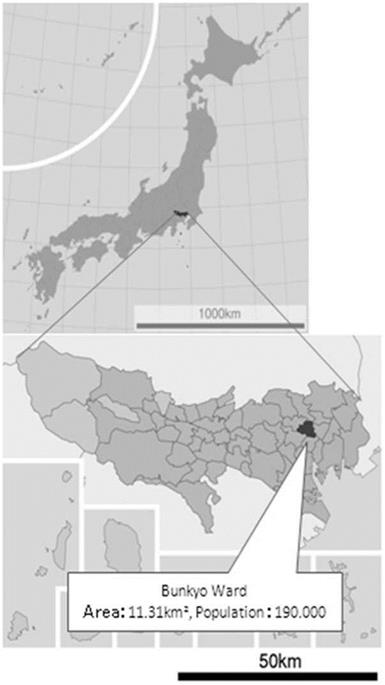
Bunkyo Ward is located in the central part of Tokyo Special district (Fig. 3.1). Tablelands, valleys, and slopes form the distinguished landscapes of Bunkyo Ward. There are many historic buildings and gardens of the Edo, Meiji, Taisho, and the early Showa era; more than 300 educational and cultural institutions, including the University of Tokyo, call it green.
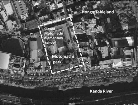
Motomachi Park is located on 1-1 Hongo, Bunkyo Ward. The area had been called Hongo, but it was changed to “Hongo Motomachi” in the Edo era (1696; in Fig. 3.2). Motomachi means “Old-Town.” “Motomachi” was used for the town name between 1906 and 1965, and the park was constructed during this period.
At that time in the Edo era, a tip of the Tableland was a viewpoint for Mt. Fuji. The scenery from there was drawn in “Ukinoyo-e,” colored woodblock prints (Tatemono Ouendan Various timelime 2006).
Motomachi Park (opened in 1930 and consisting of 3,520.44 m2) was “build after the Great Kanto Earthquake Disaster in 1923 by the City of Tokyo, one of 52 “Commemoration of Reconstruction” small parks which were designed at that time as attachment to the elementary schools, although it now is the only park maintaining the original design (Kouichi Tonuma 2007; in Fig. 3.3). Adjacent to Motomachi Park is the closed Motomachi Elementary School (built in 1927, with ground area of 4,146.76 m2). The school, originally founded in 1910, burnt down in the Great Kanto Earthquake Fire and was relocated to its present site by the readjustment of various town lots (Tatemono Ouendan Various timelime 2006).”
According to Yoko Kano, a researcher of Landscape Architecture, the “Commemoration of Reconstruction Project” indicates the modernization of Japanese society. The reconstruction of small parks and elementary schools next to each other in Tokyo was recognized as “Merkmal” (a feature) as Modern City Planning in Japan (Kano 2007).” Moreover, the historical value of Motomachi Park is enhanced by the fact that the closed elementary school’s spatial arrangement and main structures are kept in good original conditions. The other parks and
|
Fig. 3.1 Bunkyo Ward Maps Japan. http://ja. wikioedea. Org/wikiTokyohttp://ja. wikipedia. org/ wiki |
|
Fig. 3.2 The site of Motomachi Park, located in the middle of southernmost part of the ward, situated on the cliff line between the north side of Hongo Tableland and the south side of Kanda River. The park faces south to No.2 Rink; further to south runs the Japan Rail Soubu line (Google map 20110719) |
elementary schools built in the same project have already disappeared, or were reformed by war damage or by other fluctuations through times (Kano and Kawanishi 2008).
Motomachi Park and the elementary school building bear witness to the changes of time; a bomb shelter was dug during the World War II; after the War, a baseball team was organized in the park in 1950; and a temporary day care facility for children operated between 1950 and 1967.
Motomachi Elementary School was closed on March 31, 1998 in accordance with Bunkyo Ward’s public school closure and integration policy, the so-called “Domino Toppling Plan.” Because of the trend toward fewer children in the district, the Ward planned to close 7 of 20 elementary schools consolidating the students and reassigning them to 13 schools (Bunkyo Ward hp). The school building was used by Hongo Elementary School for 2 years during the process, then it was rented to two private schools for 4 years from 2002 to 2006 (Tatemono Ouendan Various timelime 2006).


