The aims of this study are to determine the contribution of pekarangan in preserving protected areas and to visualize its benefit for rural communities. When pekarangan is well managed, it can provide real benefits in term of income, nutrition, and other needs. In addition, when communities revitalize pekarangan optimally, the protected areas will be more sustainable. Therefore, those communities do not find it necessary to slash-and-burn the forest to obtain additional income or food resources.
17.2 Study Site
17.2.1 Protected Areas in West Java Region
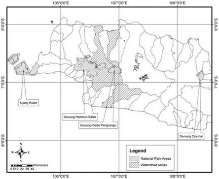
In Indonesia, there are 51 national parks: 5 of them are located in Java Island, and 4 are located in West Java (Table 17.1). The national parks of West Java are (1) Ujung Kulon, (2) Gunung Gede Pangrango, (3) Gunung Halimun Salak, and (4) Gunung Ciremai National Park. Two national parks were selected for this research, Gunung Gede Pangrango (GGP) and Gunung Halimun Salak (GHS), because they are located close to four watersheds that are being studied.
|
Table 17.1 General condition of four national parks in West Java
|
|
Fig. 17.2 Study areas of four watersheds within two national parks in West Java region. Gunung Halimun-Salak (GHS) and Gunung Gede Pangrango (GGP) National Park are located at high altitude |


