Conceptually, remotely sensed images and landscape interaction exist where imagery can provide critical information on components in a landscape study. Size, shapes, perimeter, connectivity, orientation, presence of corridors, visibility, or diversity of patches are variables critical for describing the landscape mosaic. Remote sensing has made important contributions to biodiversity conservation planning through the measurement of deforestation rates, habitat fragmentation, habitat degradation, and isolation of protected areas in human altered landscapes. By using remote sensing surveying techniques, landscape-level patterns and change are regularly monitored. From this point resource managers and planners have growing expectations of remote sensing science and landscape modeling to provide better predictions of future environmental conditions and of the impacts that environmental and socioeconomic changes may have on ecosystems and the services they provide. Such models involve the integration of multiple component models, including those predicting species distributions and habitat requirements (Turner et al. 2003).
In the first place, forest cover is of great interest to many researchers for scientific reasons and land management purposes, for which forest cover is a basic source of information for habitat modeling and predicting and mapping forest health, including landscape degradation. The spatial pattern of a changing
|
Low Medium High |
|
Level of landscape disturbance
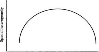
Closed canopy Gaps Cleared forest Fig. 13.1 The expected relationship between the level of landscape disturbance and the spatial heterogeneity of the landscape measured on spatial data at a spatial resolution of a few dozen meters. (From Eric 1999) |
landscape on forest cover contains information on the processes of land cover change. Of key importance for monitoring forest degradation is the integration of information from spectral, spatial, and temporal resolution. The relationship between landscape-level disturbance and the spatial heterogeneity of the landscape measured on spatial data at a spatial resolution is shown in Fig. 13.1.
Quantifying forest degradation is more challenging than quantifying deforestation. Deforestation is “direct” mapping but forest degradation involves forest “pixels,” which are complex mixtures of environment of different earth cover materials. Assessing the linking and interaction of satellite data and landscape ecology has become the essence of landscape fragmentation studies. A multiscale approach can be used to investigate changes of spatial landscape in a variety of levels between grain size and spatial extent. In a remote sensing image, grain size is equivalent to the spatial resolution of pixels, whereas spatial extent represents the total area examined (Hay et al. 2002). Remotely sensed data have different grain size, depending on their type or spatial extent, to facilitate landscape analysis and mapping according to objectives of the research. Remote sensors detect the radiance associated with a given pixel, and this information is then often converted to the spectral reflectance. Different cover types each have their own spectral reflectance. As an example of spectral reflectance in a satellite image, chlorophyll in vegetation primarily absorbs radiation in blue and red wavelengths and reflects radiation in green wavelengths. Thus, a pixel can be classified as deciduous forest, water, barren soil, clouds, and other. All this classification depends on the spectral reflectance for each satellite type. Remote sensing is now being used in the currently emerging integrated regional ecosystem consultations. Satellite remote sensing and sensor-related technological advancements have made it possible to acquire precise vegetation classification and mapping.
The development of remote sensing and GIS technologies facilitates accurate monitoring of vegetation change as less time consuming, cost effective, and highly efficient. Remote sensing and GIS have offered vast opportunities for investigation at scales larger than in the past for contemporary research into processes and landscape patterns. Many researchers believe that the integration of remote sensing techniques within analysis of environmental change is essential if ecologists are to meet the challenges of the future, specifically issues relating to global change; however, in practice, this integration has so far been limited (Griffiths and Mather 2000). The role of remote sensing and its interaction with landscape patterns are increasing in many parts of the world. The imagery, in conjunction with geospatial modeling, provides a platform for landscape characterization. Using satellite imagery, for example, Landsat TM, SPOT, IKONOS, aerial photography, and geographic information systems (GIS), landscape ecologists are able to examine how the landscape has changed over time and how it is likely to change in the future. Once landscape changes are identified or predicted, the causes and the ecological and societal consequences of such changes can be examined. In addition, the direct linkage of technology such as GIS with remote sensing and landscape ecology research allows us to integrate spatial land cover patterns and ecological processes in a manner that is essential to understanding the processes of change (Forman 1995). The advantage of using GIS is the ability to incorporate different source data into change detection applications.


