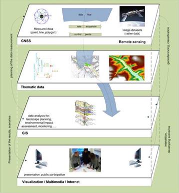
Information technologies especially GIS can help to improve the landscape planning process and to capture the results in existing information systems for future use or as part of environmental information or decision support systems (Arnold et al., 2005; Pietsch & Buhmann, 1999; Blaschke, 1997; Lang & Blaschke, 2007; Gontier et al., 2007) (see Fig. 4).
GIS can be used in the different working steps of the landscape planning process. At the beginning data capturing in all planning tasks is necessary. This can be done by fieldwork, using existing thematic datasets (e. g. via Web Services) or by converting from existing databases or other monitoring systems (e. g. remote sensing). Checking the data quality is one of the most important tasks in the first step, to appreciate the necessity of data conversion, field work or usability of the existing material. After analyzing the existing situation for the defined scope the evaluation of potential of development, environmental functions, ecosystem services, scenic qualities, conflicts, previous and future impacts must
be evaluated. Methods and tools analyzing datasets in different formats (raster and vector) or scales like spatial (resolution, grain, 2D, 3D) and temporal (historic, present, future conditions) are available. Some of them can be used for different purposes (e. g. evaluation, scenario and planning objectives) or they are only comfortable for a specific level or topic. Afterwards in landscape planning (e. g. local level) a guided vision or alternative futures should be planned and discussed (BfN, 2002; von Haaren, 2004). GIS can help to improve the participation process using visualization and multimedia techniques and Web GIS functionality. After the discussion process measurements should be planned and implemented in different ways. Monitoring of the landscape transformation must be done to check if it is really doing what it is expected to do (Opdam et al., 2002). Information management and a basic standardization are necessary to make sure that the life cycle works and in all work steps the right information in the right quality is available (Heins & Pietsch, 2010; Schauerte-Lucke, 2008; Opdam et al., 2002).
|
Fig. 4. Interaction of modern technologies in landscape planning (von Haaren, 2004) |


