The conservation movement emerged in as early as the 19th century, as a response to the negative effects of development on the land. Despite its long history, it was not until the 1960s when landscape planner Ian L. McHarg started to advocate for an ‘integrated landscape planning’ approach indicating the application of the concept in planning to establish a balance between human activity on land cover and the environment (Marsh, 2005). The influence of McHarg was significant in the adoption of an ecological perspective in land use planning, which started to take into consideration the carrying capacity of the environment.
Ecological planning developed in the mid-19th century as part of landscape planning, which seeks to safeguard the land and looks for the optimum development of ecologic-biological diversity, structural and visual diversity of the landscape (Aya§ligil, 1997, as cited in Tozar & Aya§ligil, 2008). It creates and preserves an optimum landscape pattern in terms of ecology, structure and visual aspects by protecting natural resources and seeks to balance and reduce the adverse effects of different land uses by different sectors to a minimum level (Tozar & Aya§ligil, 2008). In doing so, ecological landscape planning prioritizes the complex biophysical and sociocultural relationships taking place within a bioregion (Smart Communities Network, 2004). Moreover, another aspect of ecology-based planning is the emphasis it places on not only natural factors but also social and cultural processes that should be involved in the decisions taken about the land use (Cengiz, 2009; Dale & Haeuber, 2001; Markhzoumi & Pungetti 1999).
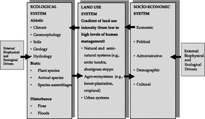
A planning methodology should consider the injuring activities in an area, their impact on ecology, and types of use affected by these activities (Bierhals et al., 1974, as cited in Altan, 1982). The Integrated Ecological Assessment (IEA) is a useful method in understanding factors related to ecosystems, factors related to human activity on land cover, and the synthesis of these factors (Bourgeron et al., 2001). Considering the scope of the IEA, its use
in an assessment study should follow three steps: integration of data (i. e. biophysical, biological, land use, and socio-economic data) (Fig. 1.), relationships between different analytical and planning activities, and depiction of spatial boundaries.
|
|
|
Fig. 1. A simple model of the relationships among regional biophysical, biological, land-use and socio-economic systems |
 |
Planning, particularly environmental planning, is a profession primarily related with the use of resources. Its prominence has increased within the last three decades due to the growing awareness about scarce natural resources and the ecological and cultural values at risk, in the face of wide-ranging problems, such as desertification, impacts of sectors such as industry and tourism, and filling wetlands (Marsh, 2005). Thus, key ecological principles are diversified, too, and they constitute a series of guidelines that demonstrate how these ecological principles are used in the decisions about land use and management (Dale et al., 2001) and consider various contexts in fulfilling multi-faceted goals (Table 5).
Landscape planning is undergoing change due to new requirements. Its previous main task of controlling spatial uses and the development of nature and the landscape has extended. Implementation of the European requirements for the Natura 2000 network, for the Water Framework Directive (WFD), the Floods Directive as well as the Strategic Environmental Assessment (SEA) can be made considerably easier and can be coordinated with the help of landscape planning.
“As general, coordinating planning, within the scope of landscape planning, existing nature conservation concepts are merged and the nature conservation sub-objectives are coordinated with each other and possible alternative objectives and measures are named. The landscape planning plans are therefore also the suitable instrument for cross-sectionally oriented coordination of nature conservation and landscape management issues with other interests and claims "(Fig. 2) (Haaren et al., 2008).
|
Fig. 2. Coordination and cross-sectional orientation in landscape planning in Germany (Haaren et al., 2008). |


