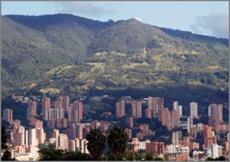
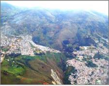
Medellin is located in a basin with, proportionally quite little flat land, which of course was rapidly occupied. This relative topographical difficulty is compensated by a very friendly climate and humidity in between the range of human comfort through the whole year.
2.2.1 Current situation
The topographical complexity is overlapped by a quite difficult social situation derived from rural forced displacement that makes the population and consequently the settlement grow not only from inside to outside but also by groups coming from distant places attracted by the urban imaginary, but stopped at the fringe. Medellin and nine more minor municipalities occupy the Aburra river valley in a closed conurbation. This physical relationship is reinforced by the geographical identity of belonging to the same watershed (Figure 4) The steepness of the slope lets the permanent sight from one side to the other, from bottom to up, vice versa, and in general overpowering panoramic views (Figure 5).
|
|
Fig. 4. Aburra valley watershed
|
|
Fig. 5. Centre-east side of Medellin
Simultaneously, with a nice view to observe, those panoramas show the uncontrolled and worrying climbing of urban occupation on the hills (Figure 6). The picture changes day-byday and in contrast to the Adelaide case presented previously, there are not enough open areas reserved. This is worst because the numerous streams that run down are being buried and their adjacent watersides completely occupied and deteriorated. To aggravate the situation, this invasion happens not only by informal occupation (Figure 7) but also by planned housing developments by high-income neighbourhoods (Figure 8).
|
Fig. 6. A sketch section of the urbanized Aburra river valley, the border moves upwards constantly and menaces with colonizing the edge |
|
|
Fig. 7. Urban growth out of control
|
|
Fig. 8. High-income neighbourhoods


